rapidtransit.net
book review
Tracks of the New York City
Subway
by Peter J.
Dougherty
Reviewed by Paul Matus Page 2
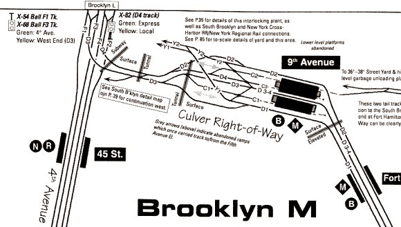
Complex interlockings, such as the junction of the
Fourth Avenue and West End subways, the former Culver Line and the South
Brooklyn (freight) Railway and the 36-38th Street BMT Yard are detailed
and explained. At one time, this junction also connected to the Fifth
Avenue L. The letter-number combinations on the tracks are the track
numbers. The reversed letters in the circles or diamonds are the letters
of the train services available at the stations pictured. Tracks of
the New York City Subway
What You
Get
The first question that may occur to many is: "If I can
get a version of these maps for free online, why should I pay for
this book?"
The most obvious
answers are portability, ease of use and clarity. The book is easy to
handle and logically laid out. Where any set of tracks moves off an
individual map page, the reader is directed to the map where the line
continues. The individual pages are large enough so that page turning is
kept to a reasonable level. A criticism is that you are directed to map
names such as "Brooklyn A" or "Midtown B," where it would be
better to be directed to a page
number.
Trackage or track
beds (structures where a formerly existing track has been removed) no
longer in use are also shown.
A nice feature of the
online maps not in the printed book is the use of color coding of
the various lines. However, this is more than made up for by the higher
level of detail in the print version. Especially useful in the print
version is the inclusion of track numbers for each and every track. On the
New York City subway system, every track is identified by a line
letter and track number. These letters are used for signalling and
identification purposes and are not the same as the familiar train
letters, such as the "A" train and the "D" train. Following these letters
on the maps helps trace the historical relationships between different
lines.
Especially interesting or complex areas
receive their own detail maps.
"Homeball
Alley," the multi-track, multi-level mile-long complex where the A,
B, C and D trains sort themselves out on their way to Upper Manhattan
and the Bronx rates its own page, complete with explanation of the
signals in the area. To put the icing on the cake, Dougherty even
explains.which services use wich tracks to thread their way through the
area.
Other difficult to
follow junctions have detailed blow-up
plans as well, including Nevins Street IRT in
Brooklyn, West 4th Street IND complex in Greenwich Village, and
Broadway Junction BMT in Brooklyn's East New York section. This latter
is (or was, in better times) reputed to be the most complicated and
spectacular elevated railway junction in the
world.
Subway yards are not forgotten either.
Twenty-three subway yards are detailed track-by-track, with interesting explanatory text for most. The
purpose of the yards, their leads and connections are covered, as well as information
about shop facilities associated with some of
the yards. Five pages are devoted to the BMT
Coney Island yards and shop, the world's biggest rapid transit yard
facility.
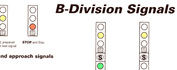
Signal illustrations help explain how signals
work, and what they mean. Tracks of the New York
Subway
|
2 |
Return to Book Review
Home
Return to rapidtransit.net Home
Everything on this site is copyright 2000 by The Composing Stack
Inc., except as otherwise noted.
Materials with other copyrights are
used by permission.
All rights reserved
Last updated March 17, 2000